


Earthquakes
Earthquakes의 설명
지진은 여러 데이터 소스를 기반으로 지진 응용 프로그램입니다.
이 응용 프로그램으로, 당신은 세계 각지에서 바로 최신 지진 정보를 얻을 수 있습니다.
또한, 지진이 과거에 발생한 검색 할 수 있습니다.
주요 특징:
- 22 지진 데이터 소스는 세계에서 가장 지진 지역의 빈번한 발생을 다룹니다.
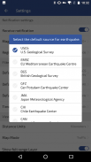
- 지진 데이터 소스
* [USGS] U.S.Geological 설문 조사
* [EMSC] 유럽 연합 (EU) 지중해 지진 센터
* [GFZ] 게르 포츠담 지진 센터
* [CWB] 대만 중앙 기상국
* [JMA] 일본 기상청
* [INGV] 이탈리아 지구 물리학 연구소
* [CEIC] 중국 지진 센터
* [IRSC]이란 지진 센터
* [TUR] 터키어 재해 및 응급 센터
* [BGS] 영국 지질 조사
* [CHI] 칠레 지진 센터
* [CAN] 캐나다 천연 자원
* [AUS] 지질 호주
* [NZL] 뉴질랜드 지진위원회
산학 및 지진학의 * PHIVOLCS] 필리핀 연구소
지구 물리학 * ROU] 루마니아 국립 연구소
* [OVSICORI] 코스타리카, 국립 대학
* [BMKG] 인도네시아 기상학, 기후학, 및 지구 물리학
* [IGEPN] 연구소의 Geofísico - 에콰도르
* [IGN] 스페인 연구소의 Geográfico 나시 오날
* [IMO] 아이슬란드 메트로 사무실
* [INPRES] 아르헨티나 연구소의 나시 오날 드 Prevención Sísmica
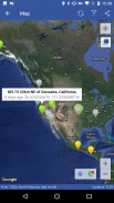
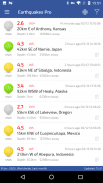
- 세계적으로 최신 지진를 참조하십시오.
- 완벽한 실시간 알고리즘은 데이터 소스가 "ALL"을 선택 (데이터의 비 중복) 데이터 소스 통합 디스플레이를 모두 달성했다.
- 바로 휴대 전화로 지진의 경고를 누릅니다.
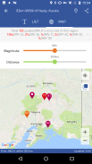
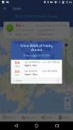
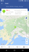
- 구글지도에서보기 지진은, 자세한 정보 표시를 지원합니다.
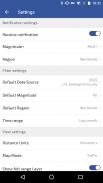
- 필터 당신이 무엇을보고 (크기 / 지역 / 깊이 / 일)
- 300km 범위의 지진으로 기록 데이터를 제공합니다.
- Epicentml 거리 (지원 수동으로 좌표를 설정 / GPS를 열어야합니다)
- 지원 내역 데이터 / 인근 / 통계 보고서.
- 지원 컬렉션 지진.
- 원본 사이트에 대한 세부 정보보기
접촉:
오신 것을 환영합니다 의견 문제 및 제안에게 문의하십시오!
- 이메일 topstcn@gmail.com
- 트위터 twitter.com/earthquakesApp
Earthquakes - 버전 3.6.0
(20-05-2024)Earthquakes - APK 정보
APK 버전: 3.6.0패키지: com.topstcn.eqEarthquakes의 최신 버전
다른 버전들


동일 카테고리의 앱


